Tuesday, January 16, 2018

April 29 2016 Chase Log

Summary
A messy day reminiscent of 2015, with a strong HP supercell riding along the 44 corridor. This day ended up being challenging due to the meh terrain and lack of straight roads east of 44, but marked my first tornado of the season. 

We started out of Norman in the early afternoon with storms going up along the dryline just west of the Wichitas. Moved down 44 as the main supercell of the day began to take shape near Saddle Mountain. Initially we were looking to stay east of Fletcher and let it come to us but with how quickly it's low-level circulation ticked up, we instead moved into position to look down the notch west of Fletcher on the east side of Lake Ellsworth. We got our first view of the storm as it was rotating like a top and rapidly turning HP at this point. It had a decently well defined RFD cut with a solid updraft base/visible rotation. This storm also displayed the most eerie green glow I've seen outside of the Elmer storm.ec990ed07414220061a9ccf00c7cdf67.jpg After encountering a confused local in an old VW bug, we hauled it back east through Fletcher and over 44 before cutting north again. Most features were not discernible from our vantage point until we got east of Cement on US 277 after popping out on Country Street 2730. The storm was pulling in inflow like crazy by this point and already had turned it into an almost as dark as night lighting situation. As a result, none of my photos of the ensuing multi-vortex tornado came out well as we closed in on Ninnekah (also partly due to my lack of a tripod in strong inflow winds). Andrew Lyons managed to grab the following photo in the distance of the tornado as it touched down.0fe256f6cb5f63476cafba02d9756011.jpg Shortly after watching it move back into the rain, we continued east on US 277. The storm's massive gust front was rapidly approaching and the tornado was completely shrouded by the time we reached the Ninnekah Truck Stop. At this point, we got slammed by high winds and heavy rain/small hail. We continued east/southeast into a worsening road grid due to the numerous creeks/streams that feed into the Canadian River to the east. We gave up the ghost near Dibbler and headed back to Highway 9 with the storm on our heels. We rode it out as it entered Norman near Riverwind Casino as it continued to choke itself off. 


Definitely not the spectacular first tornado of the season I had been hoping for after the initial frustrations of April, but a decent chase nonetheless, even with the crappy terrain and worse road options.


Chase Stats
Miles Driven: 141
Cost: $10
Tornadoes: 1
Hail: Pea (1/2")
Winds: ~60 mph (RFD)
x

April 26 2016 Chase Log

Summary

Arguably the biggest bust of the year for me and likely numerous others as well. This day loomed roughly a week beforehand, with the usual bullish shear and instability values being spat out by the GFS and to a lesser degree, the ECMWF. It had all the classic calling cards of an old-school Plains tornado outbreak. However the day of ended up being quite different, with red flags put forth by the NAM and mid-range ensembles essentially ruining the day. Chased a supercell from Elmer, OK to roughly Snyder before letting it go. The second storm we approached as it was crossing the Red River had a terribly flat, laminar base with precipitation spread through it. All in all, not the day I had been hoping for.


We left Norman around 1 PM CDT and initially moved for Lawton. The SPC threw out the now infamous PDS tornado watch as we were eating and shortly after we began to make our way down towards the Red River. By the time we reached Snyder, the first attempt at convective initiation was underway south of Crowell, TX. We moved west out of Manitou on OK5C and ended up sitting a few miles north of Elmer as the storm began to organize itself. We had a beautiful view over some open wheat fields to the south as the storm split, with the left split's base visible off to the southwest. 

0457a36eb30a93715ce8176a40fc5998.jpg

Shortly after we cut back east towards Tipton to stay ahead of any potential hail. After dipping south on OK5 out of Tipton, we stopped for a bit with some other friends to watch the storm take on a nice bell-shaped appearance. This storm also exhibited the first instance I can think of with gravity waves rippling through the anvil as the updraft grew.

56cba2196c5babe1323038f04546a5a2.jpg

2030ba0e2220199625e8a686ad283a63.jpg

eab398ae4eada672d01a906f618cff8a.jpg

About five minutes after the last picture, the storm finally managed to organize a wall cloud under a pretty hazy base. Only one attempt at a funnel ever seemed to get close as the storm rapidly became more and more HP due to seeding issues from the initial left split that had stuck around on its western flank.

b64608708629f62cc555fa1d04baff2e.jpg

We then took a somewhat ill-advised trip up dirt roads that paralleled US 183 to get a better view of the wall cloud. Thankfully we managed to make it back to OK5C west of Manitou to get a view of the now very HP storm where a lot of chasers had congregated. Our final view before leaving the storm to peek at a separate storm just across the Red River was a somewhat dramatic view of the RFD cut giving off a greenish-blue tint with the rear-flank gust front passing directly overhead.

432f40fdcde97a37c46966fe8d8e0482.jpg

14d8deb356916e0a51663aeb2ed2b917.jpg

The last storm of the day we saw ended up being a linear base with widespread precip falling through the middle of it. We were never able to catch back up with the initial storm but did get a decent lightning show on the way home. 

Chase Stats
Miles Driven: 341
Cost: $20
Tornadoes: 0
Hail: None
Winds: ~20 mph

Sunday, May 14, 2017

April 11 2016 Chase Log

Summary

An initially promising day with a readily-apparent OFB draped across north Texas. A supercell rode the boundary for well over an hour and almost managed to become fully surface-based but never appeared to be able to fully get ingest the boundary and get into the unstable air south of it. The storm would go on to drop some gorilla hail in Denton where we decided to stop for some good burgers at Rooster's Roadhouse.


An interesting triple point setup began to take shape roughly 2 days before this setup. A subtle impulse was progged to run right through the S. Plains. This day ended up being my first jaunt into the state of Texas for the year with Austin King, Kelton Halbert, Corey Godine and Sean Ernst.

We rolled out of Norman relatively early, around 11 AM CDT to head towards north Texas where an OFB from an earlier convective complex was setting up juxtaposed with the dryline. The 18Z sounding from FWD appeared promising and we made our way down I-35 with an initial target of Nocona, TX.


Although winds appeared a bit weak, initial thoughts concluded that boundary interactions and a gradual increase/backing of sfc winds ahead of the dryline might be able to pop out a tornadic supercell.

By the time we arrived in Texas at roughly 19Z, initiation was underway at the intersection of the OFB and dryline near Archer City. We moved west along US 82 towards St Jo. At this point, it became apparent that the storm was hugging the OFB and drifting ESE. After entering St Jo, we made a run for Montague/Bowie down Texas 59. We got our first view of the storm on Texas 59 between Montague and Bowie.


The storm appeared outflowish with little indication of much low-level action in the updraft region. This continued as we traipsed southwest towards Bowie, with the storm never appearing to overtake the OFB.


We cut southeast at Bowie on US 287 as the storm began to leave us in its dust. The storm became tornado warned at this point but was still visibly suffering from being on the northern end of the OFB, with a raggedy and feature-less base. However, the steep lapse rates overspreading the dryline came into play as the storm began to show signs of some serious hail. We noted a decent amount of hail falling from the storm's RFD as we continued towards Sunset.


The terrain was generally awful along this stretch and playing catch-up didn't provide any additional photo opportunities. At Alvord, we again cut east as the storm began to maintain a more easterly course and took to the county roads near Greenwood and Slidell. We were never able to fully get in front of the storm as it headed for Denton but by this point it was a full blown hailer. We experienced golf ball sized hail with some tennis balls mixed in as we attempted to beat the storm to I-35. We entered Krum and then Denton unsuccessful and still being battered by hail. At this point, we began to give up as traveling across Denton with rush hour and large hail blocking an easy way across the town.

After letting the storm drift to the east towards worse terrain and worse roads, we settled down and decided on a place to eat. Austin, being from Denton, decided to treat us to the brisket burgers at Rooster's Roadhouse and we enjoyed a heart disease-inducing dinner before driving home to Norman.

Chase Stats
Miles Driven: 389
Cost: $25
Tornadoes: 0
Hail: Tennis ball (2.50")
Winds: ~30 mph

Friday, April 14, 2017

March 30 2016 Chase Log

Summary
A frustrating day that began with us behind from the getgo. After rushing north on I-35 and beginning to cut east to keep up with a fast moving storm that was slowly taken on supercell characteristics, we were forced to give up the chase as it entered the road dead zone of Osage County. Storms would go tornadic an hour or so later in the Tulsa areas, with a particularly strong tornado near Sand Springs.


This day initially appeared earlier in the week as a possibly potent day in central/east Central Oklahoma, with a more obvious tornado threat in the Arklatex region. By the day of a 1.5-2 km deep moist layer had overspread much of Oklahoma and Texas ahead of a dryline. The biggest issue appeared to be wind profiles providing an unfavorable environment for low-level mesocyclone maintenance owing to the poor timing and entrance angle of the trough. However, by 19Z, a weak cap had been fully eroded and CI was underway across Oklahoma and Texas.


After rolling out of Norman, we continued north on I-35 for roughly an hour until we reached Perry. Storms were already trucking along and about to pass the I-35 corridor completely. We initially latched onto a storm moving rapidly ENE as it neared Perry. We attempted to keep up for roughly 45 minutes but ended up getting left in the dust as it entered the no-man's land of Osage County where spotty roads would make it harder to keep up with the fast storm motions.

At the same time, other storms had not appeared to be getting their acts together (although the initial stages of the Sand Springs supercell were beginning on I-44) and we decided to pack it in and head back to Norman as there'd be no way we'd catch up. By the time we got back, a monstrous supercell was easily visible as it was producing the Sand Springs EF3. I managed to get my only decent picture of the day from my apartment complex's parking lot.

This day left a lot to be desired and portended the absolutely atrocious April to come but it certainly was nice to see the return of skies like this to the Great Plains.


Chase Stats
Miles Driven: 188
Cost: $5
Tornadoes: 0
Hail: None
Winds: ~30 mph

March 7 2016 Chase Log

Summary

The first chase of the year on a low-end slight risk in southwestern Oklahoma. Initially moved out of Norman for far Elk City but a surging dryline stopped us from going west of Clinton, just west of a persistent cloud deck. Surprisingly decent moisture and mediocre instability failed to combine for anything meaningful, as the dryline began to slowly mix out and retreated well before sunset with little to no cumulus ever getting going ahead of it.


This day ended up being the first shot at discrete dryline storms on the Southern Plains. We initially moved towards Clinton in the early afternoon with the intent to set up along the northern end of a dryline bulge that began to take shape just west of Mangum. After reaching Clinton, we decided to move south on US 183 to Cordell where some agitated Cu was beginning to take shape just west of a persistent cloud deck along the dryline.

Unfortunately for us, as we set up west of Cordell the Cu began to rapidly evaporate in the face of a persistent inversion and weak forcing. Roughly two hours before sunset, the dryline began to retreat, essentially signaling the end of any initiation potential. We made the short drive back to Norman, none the worse for wear.

Chase Stats 
Miles Driven: 214
Cost: $10
Tornadoes: 0
Hail: None
Winds: None


Wednesday, January 4, 2017

2015 Chase Logs Completed

Happy New Year! After much ado and a whole lot of time wasting, I finally polished off my last chase log for the 2015 season. I'll be posting a somewhat detailed 2016 chase season wrap-up before I start in on the detailed logs for this previous season, hopefully in a bit more of a timely manner so I can actually keep pace once March 2017 rolls around.


November 16 2015 Chase Log

Summary

A surprisingly potent nocturnal outbreak on the High Plains becomes the most prolific tornado event I've chased in the Texas Panhandle. After initial concerns of cloud cover and meager moisture, multiple large tornadoes traipsed across the eastern Texas Panhandle, with Pampa coming out lucky after 2 encounters with some beastly wedges.


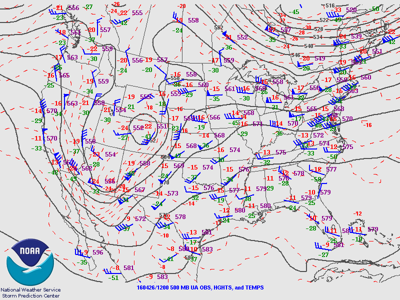
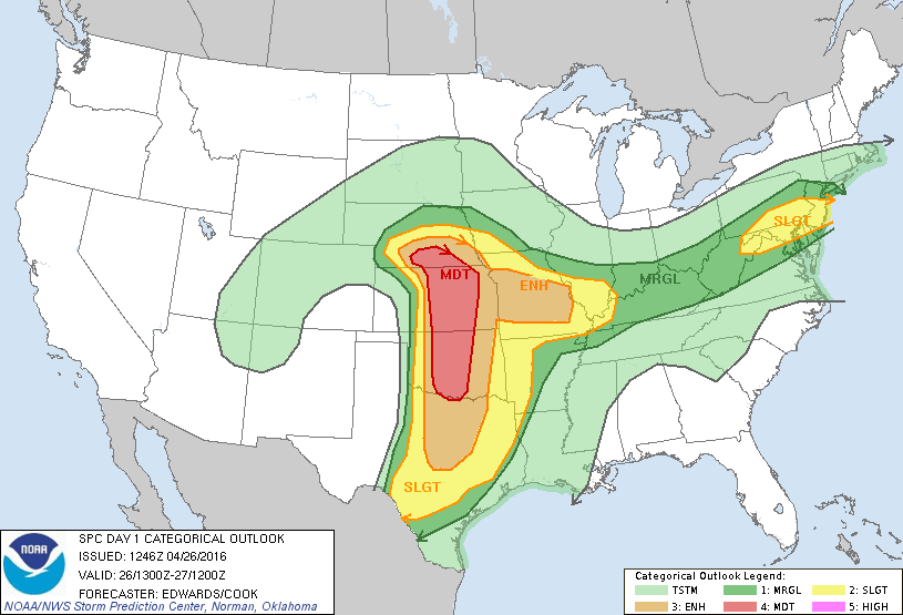
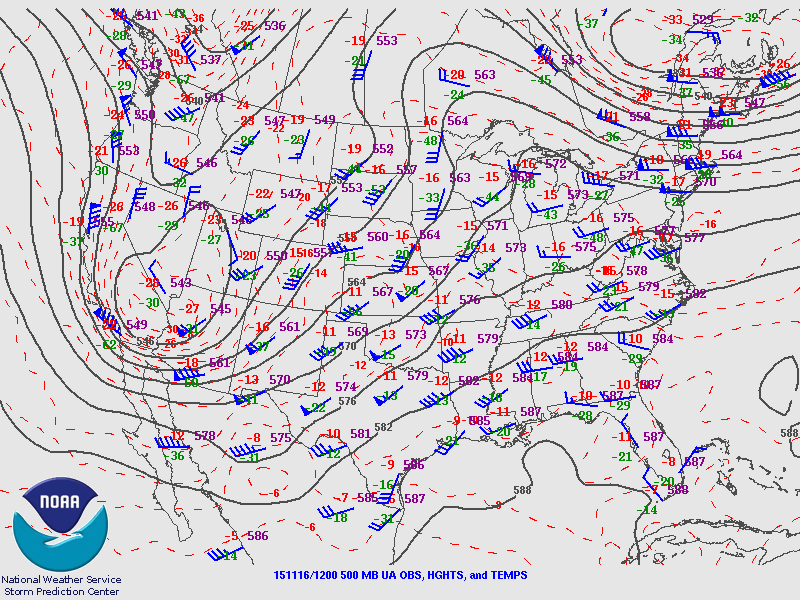
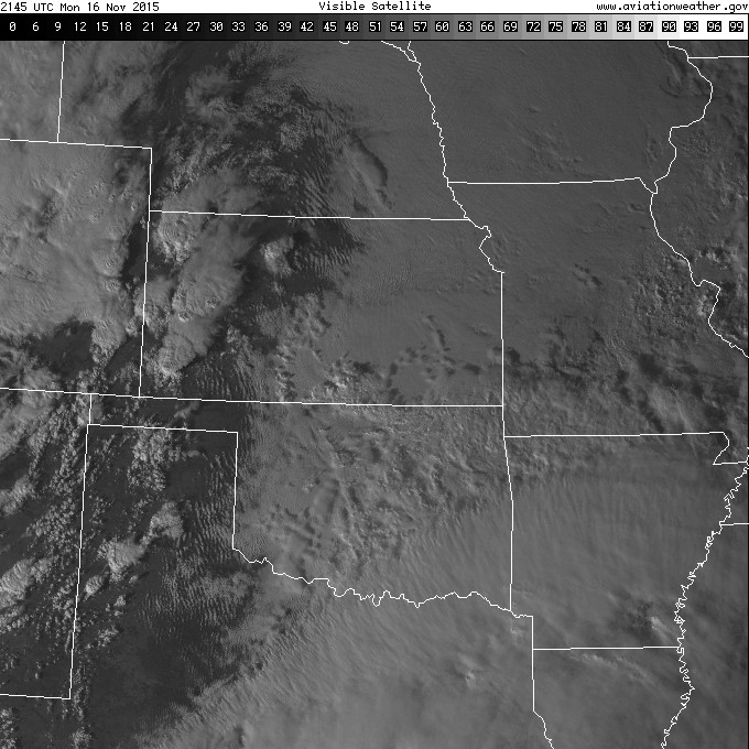
What a day this turned out to be. This day had appeared roughly 5 days out as the last hurrah on the Great Plains for some spinning water vapor, with a rather impressive trough progged to make it's way through the Four Corners region. Initial concerns of cloud cover due to rapid moisture return over southern Great Plains and southwesterly 850s across much of the Panhandle/western Oklahoma, which is almost assuredly a death knell west of the 98 degrees, appeared more and more likely with each passing run of the GFS and Euro. The trough coming in slower also exacerbated worries about a late show or a complete no go for initiation before dark.

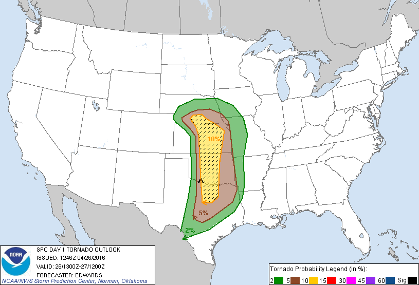
I was unable to leave Norman before the afternoon, but was blessedly able to bum a ride with Sean Ernst on his way out. It became incredibly clear by midday that the eastern Panhandle beyond the 10% was the place to be and we set off at a rapid clip to hopefully reach the edge of the Llano Estacado before things got good. As we got west of Shamrock and began our slow ascent, the first healthy looking storm of the day exploded to life near Tulia not long after 21Z.


We raced to get in position as it entered Palo Duro Canyon. As it began to make it's way into the canyon, it predictably took on a more beefy radar display, and the storm visually had a solid updraft with a massive, thick anvil. We jumped off I-40 at Texas 70 and quickly made our way past Howardwick, met up with some other people from OU in Clarendon and then ran west towards Goodnight on US 287.

Just east of Goodnight, we got our first good view of the base in fading light. A blocky wall cloud was emerging from the rim of the canyon and was rapidly drawing in scud.


We didn't attempt to move closer as we had found the perfect vantage point on the flat edge of the Llano. Shortly after the photo above, a thin funnel began to snake down and I watched the first tornado of the day briefly move to the southwest. Unfortunately, I had forgotten my tripod in haste to get out of Norman, making the shots I did get incredibly poor.


The tornado fizzled and shrank away as the base became more and more featureless in fading light.


We continued west after the tornado's death and entered the small community of Goodnight (named for Charles Goodnight, the scout and cattleman who partially owned the old JA Ranch which included Palo Duro Canyon). We stopped to watch the storm bringing up the rear but didn't note anything of particular interest as it casually drifted north towards Groom.


But as we continued west towards Claude we noted a suspicious lowering back in the rain that eventually became hazily visible as an ongoing tornado just north of Groom. We quickly turned heel and headed back east, attempting to use 287 to get leverage and then jump north. As most chasers already know the roads on the edge of the Llano are unforgiving, especially after dark, which hampered our ability to catch back up. After hitting one particularly bad divot, we decided to just haul it back to 40 as supercells continued to increase in number and tornadic activity.

Shortly after running east on I-40 we stopped at the edge of the Caprock near the Gray County Rest Area as a flash to our north brightened the base of the now beastly supercell running through Pampa. It illuminated the first Pampa wedge in full and we sat and watched as the tornado and parent supercell continue north and east away from Pampa. The parent storm was particularly impressive looking, with a very small to non-existent anvil but a rock solid updraft tower that was still visible with lightning and the last rays of light on the High Plains.

After watching this display we noted that there was no way we would catch up to the other tornadic supercells now rampaging across the northeastern Panhandle and decided to make our way home. All in all, a fantastic day that would have been my #1 had it occurred during the day (and maybe a bit further west back onto the Staked Plains).

Chase Stats 
Miles Driven: 530.8
Cost: $20
Tornadoes: 3
Hail: None
Highest Wind: N/A